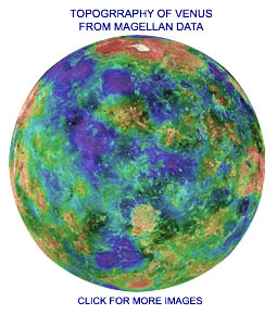
The Magellan SCIENCE Kit Fact Sheet
Part 1: Highlights of The Magellan Mission to Venus(SEE BOTTOM OF PAGE FOR PART 2 AND PART 3)
Typical Radar Mapping OrbitThe diagram shows the Magellan spacecraft's elliptical orbit around Venus, and it illustrates the radar mapping and data-transmission phases of the mission. Each nominal radar mapping orbit was the same: At position 1 in the figure, the spacecraft began a turn to point its large dish antenna towards Venus.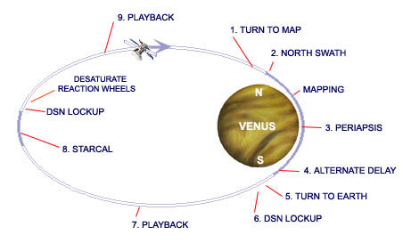
At the completion of the six-minute turn, the altimeter antenna was pointing straight down to Venus, and the dish antenna was pointing to the surface, slightly off to one side. Beginning at the north pole, as shown at position 2, labeled "NORTH SWATH," the instrument's Synthetic Aperture Radar (SAR) mode mapped a 15-mile wide swath for 37 minutes as the spacecraft moved to 66 degrees south latitude. It acquired imaging, altimetry, and radiometry data from the cloud-hidden surface of the planet and stored the data on the spacecraft's tape recorder. The spacecraft continually adjusted its attitude to point to the correct position on the planet. On alternate orbits, a 4.7 minute delay began at the north pole, followed by a "SOUTH SWATH." This technique of delaying radar mapping on alternate swaths avoided excessive overlap at the north pole, and extended coverage to 80 degrees south latitude. At periapsis, the low point in the orbit, the spacecraft's altitude was 250 km as shown at position 3. During this radar mapping phase, since the spacecraft was pointing its radar and communications antenna toward Venus, the data collected could not be transmitted to Earth in real time. Instead, all the data was stored on one of two on-board tape recorders at the rate of 806.4 kilobits per second.
At position 4, there was a 4.7 minute delay on north-swath orbits, and continued radar mapping on the alternating south-swath orbits. After radar mapping and recording was complete, the spacecraft began turning toward the Earth as shown at position 5. Six minutes later, the high-gain antenna was on Earth point, and the Deep Space Network (DSN), the worldwide tracking network on the Earth, had a minute to lock its receivers and telemetry recorders onto the spacecraft's incoming signal (position 6). After the DSN was assumed to be in lock with the spacecraft, the on-board tape recorder began to play back the radar mapping data just recorded (position 7) at a maximum rate of 268.8 kilobits per second.
Position 8 shows apoapsis, the high point in the orbit, with the spacecraft about 8,500 km above the planet's surface. Near this point, the spacecraft turned away for 14 minutes as its attitude control computer maneuvered the spacecraft through a star calibration, or "starcal," during which it automatically adjusted for errors in its attitude knowledge. It did this by first turning the spacecraft to an attitude at which its star scanner could view two known stars in one plane. It then rotated in roll so that these stars passed by the star scanner. The times the stars were seen, and their displacement in the scanner, provided the information the spacecraft's computer needed to update its knowledge of the spacecraft's attitude, and performance of the gyroscopes. At position 9 in the diagram, the spacecraft returned to Earth point, the DSN acquired the downlink signal, and the playback continued until the radar mapping data had all been transmitted back to Earth. Any data missed on Earth could not be recovered until the spacecraft was again over the same Venus longitude, approximately eight months later. If necessary, the speed of the spacecraft's reaction wheels (used for attitude control) was adjusted at this time to get rid of, or desaturate, their stored momentum. This was accomplished automatically by applying torques to the spacecraft using the thrusters. This process repeated continuously, every 3.26-hour orbit, week after week, month after month. After three 8-month Cycles, Magellan had mapped 98% of the surface.
Cycles number 4 and 5 were then spent surveying the minute variations in Venus's gravity field, which gives information on how the planet's mass is distributed, at and below the surface. This was done by having the Deep Space Network constantly measure tiny changes in the frequency of the received signal, caused by slight accelerations and decelerations of the spacecraft as it passed over more massive or less massive areas of the planet. Such gravity data could only be taken within about 30° of the equator, because Magellan's highly elliptical orbit took it too far above the surface at higher latitudes. Click the image for more information.
After Cycle 5, Magellan became the first spacecraft ever to dip into another planet's atmosphere and use the technique of aerobraking to change the shape of its orbit. The altitude of periapsis, the closest point to the planet, was lowered using thrusters, and then the atmospheric drag slowed the spacecraft slightly, so it would not coast quite so high to its next apoapsis. By the end of 730 orbits (spanning 70 days time), repeatedly dipping carefully into the atmosphere, Magellan's orbit had become nearly circular, and it took only 90 minutes instead of 3.26 hours to circle the planet. Apoapsis had been lowered from 8500 km all the way down to 500 km. From this orbit, the gravity field survey could be extended all the way from the north pole to the south pole! Cycle 6 was spent surveying the planet's gravity field at high resolution from its newly created low-altitude, nearly circular orbit. Then, having gathered more scientific data from Venus than had been imagined possible, the aging, failing spacecraft was intentionally flown into Venus's atmosphere to gather even more data while it plunged toward its fiery destruction. Magellan's mission ended October 11, 1994, having tallied 15,030 orbits of Venus. During its final few orbits, the spacecraft executed a special "windmill" experiment, designed to produce and measure roll torques, by commanding differential positioning of the solar panels. This unique experiment provided new data on the behavior of spacecraft operating in a free-molecular-flow condition high in a planet's atmosphere, and new data on material properties, as well as Venus's atmospheric density. The Magellan Project and the Deep Space Network are managed for NASA by Caltech's Jet Propulsion Laboratory in Pasadena, California. Copyright © 2007 SCI. Part 2: View a Large Illustration Describing the Spacecraft(CLICK TO VIEW)Part 3: Anatomy of Magellan's Radar Pulses
| SCI HOME PAGE | CATALOG | HOW TO ORDER | GREAT SPACE LINKS |
|